
An Ecological Assessment of
CASTLE LAKE
The area surrounding the village of Bishop Middleham has, historically, long had a wetland character, consisting of created and managed fishponds, rivers, fen carr and, most recently, ponds formed through rising groundwater levels.
To the south of the village is a large body of water formed mainly from ground water and part of a complex of wetlands surrounding the village on two sides. A series of ponds started developing around twenty years ago, with the largest and most important as regards its bird life, now known locally as ‘Castle Lake’. Although this lake is the most recent of the area’s wetlands to form, it has become, by some measure, the largest and undoubtedly the area’s most important area for birds.
Indeed, it has become a very significant site for birds in the North East, and forms a key link within the system of inland lowland wetland on the limestone escarpment in County Durham that include the larger water bodies of Hurworth Burn, Crookfoot and Hart Reservoirs and also much smaller, but still highly important ponds at Wheatley Hill, Cassop and Quarrington Hill.
The area surrounding the lake includes the River Skerne, a small sewage treatment plant operated by Northumbrian Water, a mosaic of low-lying fields with a tendency to regularly flood, small ponds and reed beds, ancient hedgerows, woodland, magnesian limestone grassland and disused railway lines.
This also offers a rich and diverse range of habitat that supports a wide range of birds and other flora and fauna. This special habitat has led Durham Bird Club to consider Castle Lake as one of the most important inland sites in North East England.
To enhance the site in terms of birdlife, Durham Bird Club has been working with the landowner farmer for the past fifteen years to develop the lake utilising its natural profile to create a series of breeding islands, scrapes and reed beds to support and maintain important breeding birds.
Castle Lake is also important as its geology is underlying magnesian limestone rock, typical of the local area and very important nationally as part of the Durham Magnesian Limestone Plateau, one of England’s 159 National Character Areas, as defined by Natural England.
A magnesian limestone outcrop stretches from Nottingham northwards through Yorkshire and into County Durham, where the Durham Magnesian Limestone Plateau extends in a broad triangle south-westward from the North Sea coast, to the valley of the River Wear to the west, and south west inland to Newton Aycliffe.
This geological landscape provides a specialist and rare habitat attractive to a distinct range of flora. The Durham Plateau includes 4 sites designated as National Nature Reserves, and a further 52 Sites of Special Scientific Interest (SSSIs), thus underlining the recognised high level of flora and fauna within this zone.
The Plateau is characterised by an open, agricultural landscape, a limestone escarpment to the west and the Magnesian Limestone aquifer that sits below the area, which is thought to be the main water feed to Castle Lake.
Castle Lake is located on the very southern edge of this geological zone, with the River Skerne roughly marking the border to the more open plains of the Tees Lowlands, some features of which, such as low-lying wetland, can be found in the immediate environ surrounding Castle Lake, for example the A1 Flashes ((Natural England (2013a); Natural England (2013b)).
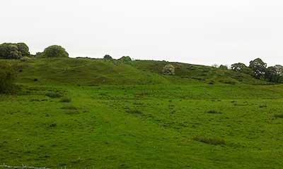
Castle Lake has a rich history. ‘Castle Field’ at the north end of the site contains the earthworks (now a scheduled ancient monument) of Bishop Middleham Castle, the principal seat of the Prince Bishops of Durham from about the eleventh to the fourteenth centuries.
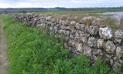
At the same time, a number of causeways were built across the marshy ground to aid transport and manage water levels as there was an extensive series of fish ponds, shallow pools and narrow sluices all to provide fish to the Bishop’s table. Although it has been called a castle, it was not a true fortification, but a well-guarded manor house. These constructions are still in existence, as is a deer park wall, of medieval construction, that enclosed a deer herd intended to provide fresh meat and hunting for Bishop.
Much of this wall is still in existence and it runs the length of Foumarts Lane and neatly encloses Castle Lake and its surrounding pasture (Durham County Council, 2012). Today, the area surrounding the lake has a network of numerous public footpaths and bridleways. Large numbers of walkers and local residents frequent the area to enjoy the natural environment and they take great pleasure in seeing the wildlife.
Castle Lake began to form approximately 20 years ago; the presence of field fence lines and posts through the lake provide testament to the relatively infant nature of this water body. The location map of the site also illustrates the previous field boundaries. The lake and surrounding pasture is part of a larger wetland complex surrounding Bishop Middleham. This includes a number of permanent and semi-permanent lakes and wetlands, including Fishburn Lake, ‘Stoney Beck Lake’, ‘Alan’s Pools’ and the ‘A1 Flashes’.
These sites are also noteworthy semi-permanent wetlands within their own right, but together they form one of the largest and most an important wetland systems in the county. All of these sites are situated close, or adjacent to, the River Skerne flood plain.
Fantastic range of Bird life
A FEW FACTS
Recorded Species
Species recorded in 2011
Species seen in Summer/Autumn
Species of Wader